15.7.12

Cycling through Yunnan

Yunnan, known for its tea and rice-terrace fields; banana & teak tree plantations; wild edible mushrooms; spicy food, spitting locals & stinky toilets; colourful traditional clothing; beautiful Dai, Bai & Naxi villages, & totally enjoyable, gradually inclined mountain roads with magnificent valley views.

Landscape
The entire Yunnan province is stunningly beautiful to cycle through. We’ve been through national parks, botanical gardens, up quiet mountain paths & through some ancient villages too. The mountain roads are incredibly gradual in inclination, making the uphill cycling last a lot longer yet feel completely painless as we zigzag our way up, only to descend the other side again, in front of yet another climb. The mountain views are breath-taking, their peaks are covered in snow and their slopes packed with lush green vegetation so delicately prepared and cared for.


We have seen neatly organised terraced rice fields & carefully cut tea tree plantations, and we’ve watched how the locals grow, clean and collect their crop from their vast land. The women tend to work in the fields more than the men; we've spotted the men in the local restaurants & bars playing games all day long whilst drinking bottled beer. Women even get to work on construction sites, shovelling sand, stone and throwing bricks up to others to build walls.


We have also cycled alongside the deathly cliff edges of the Tiger Leaping Gorge, where only a thin white painted line separated us from the huge drop. We have visited the White Water Terraces, formed over thousands of years from the deposits of calcium bicarbonate dissolved in spring water. We also spent a night in Shigu, a town by the first 180-degree bend of the 6418km long Yangtze River. The following day we experienced an optical illusion after crossing the river by boat - thinking we were on one side of the mountain which defines the river bend, yet we had somehow already cycled round to the other side; we would be totally lost without our GPS!

We also cycled over a 2950m mountain to an ancient village, Shaxi, known for being on the Ancient Tea Route leading from Yunnan to Tibet. More recently we cycled up to 3722m before a long chilly decent through a green valley with free-roaming yak, goats, horses, ponies and pigs, before reaching the city Shangri-La.


Food
All restaurants here have small stools and short-legged tables, making us need to crouch in a typical bicycle-position, over our bowls to eat. Our knees go through torture sitting on these short stools, often being banged into the table edges, yet the variety of food on offer allows us to forget these little burdens. 


The food ranges from dumplings small & large to different meats cooked in garlic or chili together with an assortment of green leaves; we have also tried yummy dairy products from goats and yak. There are also sadly a lot of flies in this part of the world and we spend much time flapping them away from our bowls of rice or noodle soup in order to enjoy the food fully.
In one of the last mountain villages we visited, before arriving in Shangri-La, we ate in someone’s house together with many men who slowly wandered in, expecting to be served their noodle soup, as usual. After attempting to make conversation with one of the locals we were asked to follow him through the village. We walked through the dark and were stunned to suddenly come upon 100 men in black & red costume, dancing to their local anthem in a basketball court. We sat and watched them all dance in rhythm at the same time, yet during their breaks it seemed like we stole the attention, being the only white people there. 


Noise
The Chinese are not short of being the noisiest people on the planet. They speak loudly to their companions only centimetres in front of them; they talk loudly on the phone; they beep their loud car, motorbike & truck horns - so loud we needed to cycle with rubber earplugs for a week; (we feel we might become deaf before we return home.) They are loud in hotel corridors, slamming doors or laughing in conversation with their companions, not seeming to realise they are in a hotel where others might be resting.
Not only do the drivers honk loudly, they also drive like suicide drivers; on leaving the city Lijiang we saw several accidents as drivers continuously attempted to overtake without looking – even just before corners, or even moving out to find themselves right in front of a car driving in the opposite direction. They never look out or back when turning into a main road & just don’t pay enough attention to others on the road! The only thing that keeps them quiet is smoking massive bongs, which the men here do most of the time!


Architecture
The most spectacular part of the Chinese Yunnan buildings is their decorative tiled roofs. We have seen styles from the ethnic minorities; Dai, Bai, Naxi and also Tibetan. The traditional Yunnan house always opens to a courtyard space, around which the living rooms are organised. The toilets are often nowhere to be seen.. so if you’re ever looking for one in this part of the world, try listening out for the snorting of a pig, as the toilets are always right beside the pig huts!

We’ve cycled by some picturesque Bai houses in the Dali region, all made from brick and wood, with white-painted walls and hand-painted scenes in blue, depicting dancing people, local nature, birds & animals. We have also seen Naxi handmade wood houses in the mountains. Now closer to Tibet we see more clay-brick & mud-made houses, with exterior walls which slant inwards like those of a pyramid. Even the windows of these houses have a slanting frame imitating the walls. We have also seen many colourful temples, old & new, with fabulous layers of roofs painted in reds, greens & blues. 


We have met a few Chinese cyclists on the way; all heading to Tibet of course and making us terribly envious as a result. We cycled a couple of days with some single cyclists we met; our Greek friend Petros, a French girl called Agnes and an Irish lad, Robert, whom you can easily spot in our photos!

Cycling through Yunnan is so relaxing when passing by the mountains or along rivers. We only wish we could inspire you to come and do the same.

13.7.12

Cycling through Central Laos & Northern Thailand

We spent a week cycling around central Laos visiting some famous caves, including the 7km long Konglor cave, which you should definitely go see if you ever visit Laos! Our way of getting there was by cycling & pushing our bikes up & down some very narrow and steep muddy trails and streams, whilst passing the occasional remote village, rice fields & grazing water buffalos. As Sertx was cycling down one of the paths, a young girl pulled out her machete just to show him that she was not scared of the bearded man (the villages were that remote!) 
Once we arrived at the cave we needed to spend another 2 hours convincing the boat drivers to take our bikes on their small, narrow boats for less than the usual bike price, which always seems to be as much as a ‘person’ ticket. We guess they weren’t happy with the outcome, as Sertx’s bike was dropped & sunk into river! The boat ride lasted an hour, which included having to get out and walk in complete darkness across shallower sandy parts a couple of times. Only the boatmen had powerful enough head torches to light-up the vast cathedral-like cavern. This cave was really an unforgettable experience and unfortunately the only place we could not take any photos as it was pitch black inside. 

 
Our Greek friend Petros caught up with us for a day here after cycling through the country on muddy off-road tracks, on which he continued after leaving us, only meeting us again in Laos. We stuck to the asphalt road, cycling passed tobacco-leaf fields in valleys, and up some very steep mountains only to descend their other side steeply, all on our way to the capital Vientiane, from where we crossed over the Mekong into Thailand. Whilst crossing the ‘Friendship’ Bridge I somehow, inadvertently managed to get my front tyre stuck in a train track, thereby flying off and over my bicycle for the first time.
The beautiful tobacco fields of Konglor
 
We spent the first 2 weeks of May cycling through Northern Thailand; One week on undulating roads following the Mekong westwards towards Uttaradit & the second week resting in Chiang Mai then cycling over a few mountains back into Laos again. We thoroughly enjoyed riding these peaceful roads until our third 100km-day where we met some seriously, illegally steep mountain roads that we were forced to get off the bikes & push them up the more than 12% inclined slopes.


We were gratefully rewarded with stunning valley views for every mountain we climbed, however, some massive, biting horseflies managed to catch up with us on our last slope of the day, resulting in us rapidly hopping back on our bikes & spinning our pedals as fast as we could, whilst they flew into our eyes & ears & even tried to nest in Sertx’s beard. Sertx looked like a human windmill trying to fight the horseflies away. 


Although most days on the bike were spent cycling under the intense heat of the sun, we also experienced cycling through several thunderous rain showers, where we needed to dodge leaping frogs & scuttling crabs on the roads!

We accepted an offer for a lift from a friendly Japanese-Thai local, who drove us over many mountains, and across a few towns in order so that we could catch an afternoon train to Chiang Mai – so that we could spend more time exploring the north before our 15-day visa expired. Even though we rushed it was only after arriving at the station that we discovered that large luggage was only allowed on the 5am morning train; the following morning we also discovered that the 5am train is always 3 hours delayed. 


Once in Chiang Mai we picked up our front panniers & rack pack bag, which were filled with our winter clothes & camping kit for the months ahead. Sertx now carries 28kg on top of his 14kg bicycle & I carry 10kg less than him. So since then I’ve been racing up the mountains in front of Sertx for once, who is only slightly suffering from carrying the heavier load. Riding our bicycles now feels as though we are steering a caravan! 


After crossing the Mekong again, we spent 3 days cycling through 40 degrees C. temperatures over the steep mountains in Laos to our final stop in Luang Namtha. From here we spent a day renting a motorbike to explore a town just 58km away, yet only made it 50km to see a waterfall, before a thunderstorm caught up with us. On this occasion we forget to pack our raingear, and ended up soaked to the bone & shivering on the windy & winding motorbike ride back into town.


Laos is breathtakingly beautiful throughout the country, and would make a fantastic trip if only you have the perpetual patience to wait until the locals understand anything you ask for, even when you ask for it in their own language! As for Thailand; that is a country we would happily cycle through any day again!
I swear I didn't knock that lorry over!

12.7.12

Our Summary of Cycling through SE Asia

We spent February, March & April cycling 4280km through Southern Thailand, Cambodia & Laos.
In Thailand we met Dutch, British & French touring cyclist couples almost daily, all heading the opposite direction to us. In Cambodia we met touring cyclists from Canada, Mexico, Switzerland, Germany, Korea & China. We hadn’t cycled with anyone until South Laos when 3 cyclists suddenly caught up with us, heading the same direction -two of them sharing a bright yellow tandem! So we joined forces & cycled together for a few days then continued to cycle along with our Greek flip-flop friend, Petros.

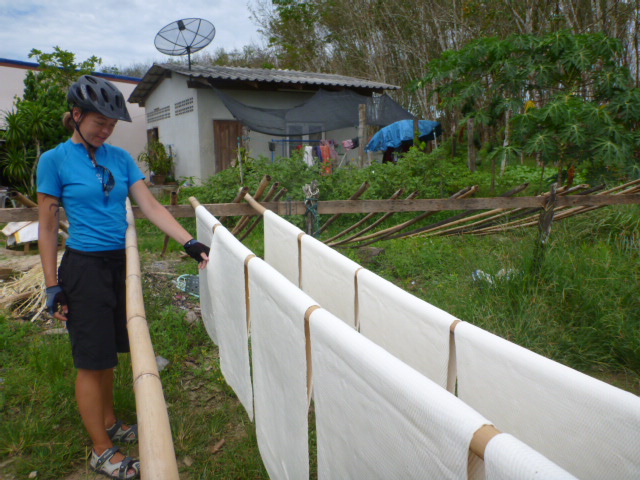
Apart from seeing hundreds of golden Buddhas our trip through Southern Thailand was incredible; we were able to cycle on dirt tracks, (thanks to our GPS) compared to the asphalt roads we needed to stick to in Malaysia. So we have been sliding our wheels through sand, loose rock, dirt & mud, all under a hardcore sunshine and occasionally through a torrential rain shower. We cycled through a trazillion rubber tree plantations, watching the entire process from collecting the latex, to squashing it into flat white sheets, which are then hung over bamboo poles to be dried out in the sun, and then piled onto a lorry and taken to a warehouse, from where they are eventually sent on to China for processing into such uses as bicycle tyres.

We also cycled passed salt fields where the workers wear ‘fonejacker’ woolly masks to protect their skin from the sun! We have also observed how durian, coconuts, pineapples, papaya, bananas & mangos are grown, collected & transported & we also visited a famous floating market in Samut Songkhram where such fruit is sold. There we got the chance to see the Thai princess at an old-style theatre-dance performed specially for her. We also took 3 weeks off cycling to explore the beach islands of Koh Lanta, Koh Tao – where I completed my Dive Leader/Manager course (hurray!) & Koh Samet, where we visited a fishery with Sergio’s parents. We tried a few Thai massages, which Sertx ended up hating, & I had a fifty fish nibble away at my feet, which took some time getting used to. We also ate ice-cream with a mountain bike champion in Don Sak who helped fix my bike brakes.

In Thailand we had cats, dogs, chickens, water dragons, snakes & tarantula-like spiders jump in front of our wheels; in Cambodia it was just the crazy drivers who almost ran us over and in Laos we had larger animals such as cows, water buffalo & goats casually walk into the road making all the traffic stop. We have had dogs tiny & large barking and chasing us as well as locals speeding passed us shouting ‘hello’ from their mopeds & staring back at us in amazement, whilst they continue to drive on. Dogs are born on the roadside & so are used to jumping in & out of the way, just as babies are born riding scooters – we’ve seen kids as young as 5 driving by us!


We did some of our longest cycle days in Cambodia; our lengthiest being 145km, but we also took 2 weeks off in Siem Reap to see the Angkor Wat temples, visit a crocodile farm, see 3 Child Dream Schools & also get both our bicycles serviced. We got to cycle alongside students cycling to school, as well as forest fires and some maniac Toyota Camry drivers and also heard a few too many children screaming ‘hello’ endlessly. Thankfully there are no dead animals on the road, the reason, which we came to discover, was that they throw almost anything on the barbeque! We watched some incredible sunrises & sunsets over the Mekong River & also went on a boat trip to try and spot an Irrawaddy dolphin.

Laos is breathtakingly beautiful. The roads are better than in Cambodia, & they have road signs & speed limits, unlike in Cambodia. We have seen more concrete houses, rather than just tree leaf huts; more babies wearing clothes rather than walking around naked; women wearing normal clothes, not colourful pyjamas all day long; and less screaming kids - families having 2 kids, not 6. However, here no one speaks a word of English, unlike in Cambodia where the locals understood our sign language. Here in the south, we have cycled through sandy islands along the Mekong, passed coffee bean plantations in the mountains, and swum in some mega big waterfalls.


We were in Laos for the Asian New Year which coincided with the week-long water festival - where the locals were drinking too much alcohol & throwing buckets of water at us cyclists from the side of the road, rather than lying calmly in their hammocks as usual. We also changed our road tyres to 2-inch-wide off-road ones to cycle 1324m up to the Bolaven Plateau to visit some beautiful waterfalls. Only days after we were cycling & pushing our bikes through a jungle terrain along the rocky Ho Chi Minh trail which was the hardest thing we’ve ever done. In this off-beaten track we found an American tank and saw local villagers exchanging metal war junk for Vietnamese sweets!


I’ve experienced head pains, tummy pains, muscle pains, knee pains and shoulder aches; yet Sertx only feels bicycle pains, becoming frustrated when another wheel spoke snaps, or the inner tube punctures, or the Rohloff hub leaks black oil everywhere, or the tyre is too wobbly to ride with. 
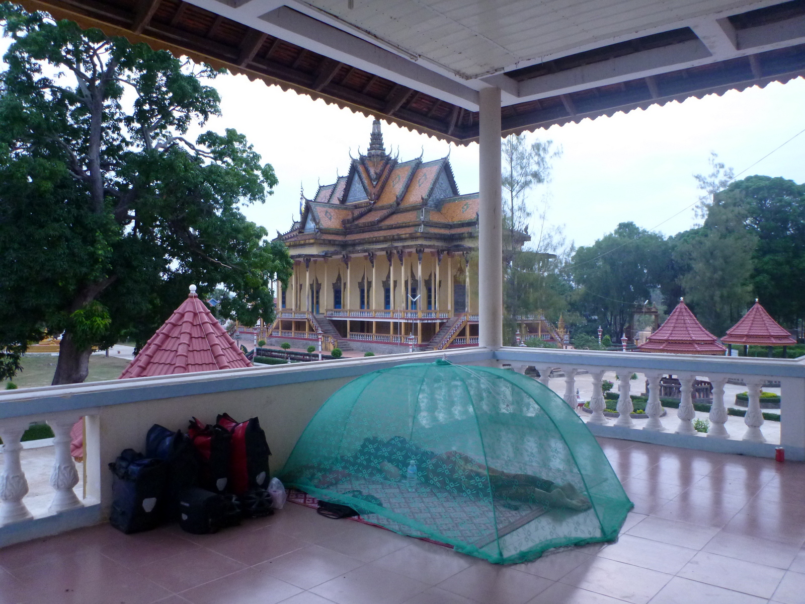
We’ve experienced sleeping in a thin-walled love motel in Thailand, on an ant-infested balcony floor of a monastery in Cambodia, and have also spent a few nights in homestays in Laos, where there is no clean water - having to wash ourselves in a nearby muddy river or from a barrel filled with old water.

This photo was taken by Petros


Our thighs are thinner but our bellies are bigger; I ate lotus fruit in Kratie, whilst Sertx ate a locust in Yan Ta Khao. Every morning the thing we look forward to least is the torture of pulling on our sweaty lycra padded pants, but what we enjoy most is being able to experience time with the funny locals by cycling through their land. Our experience of each country just becomes more insightful & the routes definitely tougher as we cycle on northwards.

Supporting Child's Dream to Build a School in Laos

In March we cycled 140km each day for 3 days to visit 2 schools by Child’s Dream, which were located in the most remote part of northern Cambodia. We cursed our way through sandy paths and off our GPS route through jungle terrain, praying not to be eaten by a tiger in the Kulen Prum wildlife sanctuary we were cycling through. 
We saw the current conditions the children are taught in; the village locals have built small huts out of bamboo & dried out palm tree leaves to act as a classroom under which 200 students need to be taught. During the monsoon months the wind & rain water disturb the lessons and in summer the heat is uncomfortable to concentrate in; all this in a malaria prone area.

The new schools built by the Child’s Dream charity follow government approved construction plans & designs. They are made from concrete, have high ceilings for hot air to rise and large windows for cool wind to ventilate through and altogether provide a comfortable learning environment. Teachers are provided & paid by the government and the schools are also provided with classroom furniture, toilets, a playground, a ground-water hand-pump for drinking water and one school even has a solar powered battery charging station, for producing electricity for use by the village! 


All in all Child's Dream aim to create effective, efficient & sustainable projects whose progress they continue to monitor.

In Cambodia:
45% of children just end up working in the fields for their parents
More than 50% of all school children cannot afford to continue their education after primary school (from the age of 12 onwards)

In Laos:
20% of all villages do not have a school;
Only 15% of the population have completed primary school.

Child's Dream also support a sustainable agricultural project; NEED-Burma. This Network for Environmental & Economic Development project is an attempt to act as a catalyst for progressive change in Burma. NEED's Model Farm Initiative (MFI) is a six month professional development training program in sustainable agriculture, environmental justice, community development & leadership for ethnic minority youth from Burma. The participants live, work & learn at the farm & training facility in order to implement these skills back in their country. We spent a day being shown around the farm, which is located only a short distance from Chiang Mai.

 
We also cycled up more steep side roads in northern Thailand, close to the Laos border, in order to visit one of Child's Dreams nurseries.

Our website has a photo page of all our visits: 
Child's Dream images 

Help us fulfil these children’s dreams!


Thank you to all of you who have already kindly supported the charity through your donation!
To those of you who haven’t (and promised)… - just think that as little as $5 will help support a child.
Please help by clicking on the link and making a donation: www.cyclingarchitects.com/donate


Whilst in Chiang Mai we cycled to the Child’s Dream headquarters and met with the founders, with whom we discussed the options for which school your donations could go. They confirmed that we could choose the country in which we would like the new school to be built, & that it would be possible to monitor costs, construction & follow all building stages, including post completion. 

We are currently in the process of choosing a Secondary School project in Laos. If you make a donation we will keep you informed of the progress over the next couple of years.

25.4.12

The most Comfortable Cycling Saddles

Sergio has a Selle An-Atomica mens saddle & I use the Brooks B-17 S Standard ladies saddle for our touring. 
We chose these two because they are apparently the ‘very best’ of touring cycling saddles.

It took about a month for Sertx to get used to his saddle. His bottom was numb & swollen in pain for the first 2 days - yet we cycled 100km long days. Nevertheless, he reckons he got used to it quickly. He still felt pain in the soft bits after 1000km, so he tensioned/increased the bolt in the front part of the saddle, which alleviated the pressure. Sertx also turned the angle of the saddle towards the left as his left leg is shorter than his right; this actually worked, reducing the discomfort he felt in his upper thigh. Sertx knew about the adjustments one could make to the saddle after reading the saddle adjustment instructions. After 5000km on this saddle Sertx is riding comfortably even without padded pants or chamois creme.

The B-17 S Standard Brooks saddle fitted me from day one. I wear super duper H FI.Lady S5 Assos polyamide, padded pants and find the saddle great to ride 100km long distances with; however, if riding just a short distance without padded pants I feel my bones pushing into the hard leather, which is not really that comfortable. I spent some time adjusting the tilt of the saddle – notch by notch until it felt in the right place for me (other female cyclists have sat on my bike & told me it's really uncomfortable for them - so the saddle really only fits & works to your bum). We have met many touring cyclists with Brooks saddles who don't wear padded pants anymore, yet I guess it will take me more 10,000km until I can ride without padded pants, as I'm still slapping on chamois creme before each ride & skin repair gel after each ride. Overall it is a great saddle for 80km cycling days!

How to use Google Map Tracks & Embed Tracks on your Website

Below are 20 steps to creating a track in Google maps, converting it from a kml file to a gpx file for transferring it to your GPS device, then downloading your recorded gpx track & converting it back to kml for use in Google maps & embedding your tracks on a Google Map in your website, as I do it for our website. You will need to setup a Google Maps account & download Google Earth for free. I use a Garmin GPSmap 62s device & MapSource.
  1. Sign in to your Google account and click on ‘Get directions’. Use the boxes to write in your location & destination. Google will create a blue track between your points ‘A’ & ‘B’, following roads & tell you the distance & detailed directions to your destination. You can click on the track to add a point, which you can then drag around to include other roads. You can also type in a search item, such as hotel/hostel/guesthouse & the map will display all the hotels in the area; you can right-click on any hotel and select ‘Directions to here’ to change your destination.
  2. Once you are happy with your track you need to save it; scroll down on the left side toolbar until you see a ‘Save to My Maps’ button. Select 'Create a new map' & click on the 'save' button save the track to the 'My Places' folder. Your track will open in a new window and you can 'Edit' it further (change the name or colour of the track).
  3. After saving the track & clicking on 'Done' you have the option to export it as a kml file. Click on the ‘kml’ link & save in an appropriate folder.
  4. Use this link to convert the kml file into a gpx file for use on a Garmin device:                GPS Visualizer
  5. Save the gpx file to an appropriate folder eg: ‘Planned gpx Tracks’ with a suitable filename.
  6. Open the file in Garmin MapSource for transferring onto your device. Note that for some Garmin devices you will have to reduce or ‘filter’ the track points to 50 before transferring it; Do this by right-clicking on the track & selecting ‘Track Properties’, then ‘Filter’; where you have the option to reduce the points to 50 ‘Maximum Points’. Click ‘ok’. Check the ‘Name’ of the track is as you want it then click ‘ok’.
  7. Connect your GPS device & transfer the track. Disconnect your GPS device, and then turn it on to check your track was transferred, under ‘Main Menu’/’Track Manager’. There you will find the track under the name you saved it; select it and ‘View Map’ then simply select ‘Go’ to follow it.
  8. The GPS device will create a new track of where you’ve been, under ‘Current Track’ in the Track Manager. When you’ve reached your destination you can save the track & transfer it back to MapSource for use on your website. Depending on how many days you’ve travelled, the Garmin device will either combine the tracks under ‘Current Track’ or store them under ‘Archived Tracks’. The Garmin device also gives you the option to save tracks daily in its Main Menu. To transfer your current track, go to ‘Track Manager’ and select ‘Current Track’ and ‘Save Track’, as the date filename they suggest.
  9. Connect your GPS device to your computer; the device will ask ‘Connect to Mass Storage’; select ‘yes’. A new window will open on your desktop. Click ‘Garmin’/’gpx’ and find the saved current track under the date you saved it. Copy this over to a suitable folder on your hard drive.
  10. Open the track in MapSource. Right-click on the track & select ‘Track Properties’. Change the track ‘Name’ to something, such as the location, which you want people to read when they click on it through your website.
  11. If you want to group several days of tracks under one long track you can simply ‘select all’ in this properties box, click ‘copy’ and paste it into another file with a track – in the correct date order (I click on ‘end’ at the end of the points to paste more tracks). If you want to split combined tracks into separate tracks save a copy of the track then delete selected points by date.
  12. Your Garmin device will have saved several points per track (seen under ‘Index’ in the properties box). Unfortunately Google Maps can only store about 300 points per track before it starts splitting one track into two or more. So again we need to ‘Filter’ the points to a maximum of 300. You can either follow Step 6 above or after clicking ‘Filter’ select ‘Automatic’ & ‘Fewer Points’. You might have to do this a few times until your ‘Index’/points number reduces to around 300. By reducing points this way your track will become less rigid between points, sticking to the bends in roads for example, rather than jumping them.
  13. Save the filename as a ‘gpx’ file, under an appropriate name; I always add the number of track 'points' to the end of the filename, eg: ‘Laos Tracks-300’, and keep a copy of the detailed file with all the points.
  14. I use Google Earth to open this gpx file to convert it into a kml file; Open your file in Google Earth selecting ‘All files’ to find the ‘gpx’ file. Select ‘Create KML Tracks’ & ‘Adjust altitudes to ground height’. The track will be shown in blue.
  15. Right-click on the track & select ‘Save Place As…’ then choose a new folder, such as ‘website kml tracks’ to save the file in, and select ‘kml’ to save it as a .kml file.
  16. Now you can upload this into Google Maps. Sign-in to your account; select ‘My Places’, then ‘Create Map' and 'Import' to upload the .kml file.
  17. Hopefully only one track will be created, not a split track. You can then edit this, change the colour of the track & name & add any markers. To view the track as ‘miles’ I use googlemaps.co.uk but if I want to have the track in ‘km’ on my website I sign-in to googlemaps.de
  18. Once you’ve saved your track you can choose to view it in either satellite, or simple street-map or terrain mode; I choose the ‘terrain’ background for our website, as when you zoom in you can also see the contour lines of the mountains we cycle over.
  19. To save a script of the map click on ‘Link’ (beside the 'printer' button in the side toolbar) & ‘Customise and preview embedded map’. (If you are not able to select this try logging out & in again.)
  20. A new window will open where you can customise the size of your map. Select and copy the HTML script to embed it onto your website. I use Basekit.com for our website, which has an ‘embed’ widget where I can easily paste the script into.

Hope these steps help. This is the way I plan our cycle tracks.
Comments or suggestions below please!

23.2.12

Sigg Water bottles for cycle touring

We like our 0.75L wide-mouth, Swiss Sigg sports aluminium water bottles; & carry 3 per bike. 


They are lightweight, leak-proof, keep the water cool, keep the taste of water neutral & work well for our usage. We chose to get the wide mouth version and the sports top which has a press-release nozzle and mud-guard cover. We can therefore use any of 3 openings to drink from or fill water from other bottles into. The bottles come in several colours, either with or without the moulded grip, they are free of harmful chemicals and 100% recyclable! 
We really like our water bottles.